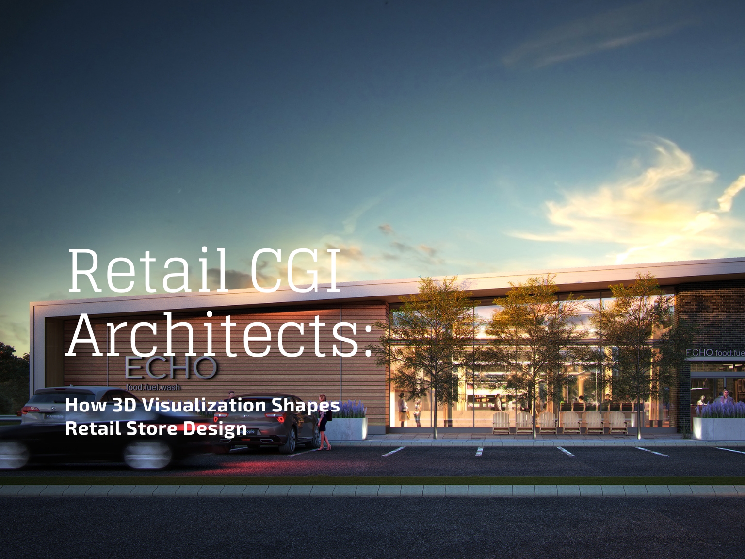
Why 2D Plans No Longer Convince Clients and Stakeholders
If you’ve ever presented a beautifully detailed 2D site plan to a client, only to be met with polite nods and puzzled looks, you know the frustration. Most clients, investors, and decision-makers cannot can read technical drawings. To them, a 2D plan is just a flat puzzle of lines, shapes, and labels.
Professionals lose opportunities when stakeholders can’t visualize the end result. A missed detail in a pitch or a misinterpreted layout can cost weeks of negotiation or open the door for competitors who present the same idea in a way that instantly clicks. That’s where 3D site plan rendering changes the game.

What is 3D Site Plan Rendering?
3D site plan rendering is the process of transforming technical 2D site layouts into lifelike, three-dimensional visuals that accurately represent a property’s overall design and surroundings.
Instead of relying on imagination, stakeholders see exactly how buildings, roads, pathways, landscaping, and surrounding areas will appear once completed. For industry professionals, it’s both a communication tool and a sales asset, bridging the gap between concept and commitment.
2D vs. 3D Site Plans
2D Site Plans
- Flat, top-down diagrams showing dimensions, layout, and key features
- Excellent for technical accuracy and construction planning
- Often hard for non-technical audiences to interpret
3D Site Plans
- Adds perspective, depth, and photorealistic details
- Shows textures, materials, lighting, and environmental context
- Allows clients to visualize the finished project instantly
- More persuasive in marketing, pitching, and approval processes
The difference is simple: 2D explains; 3D convinces.
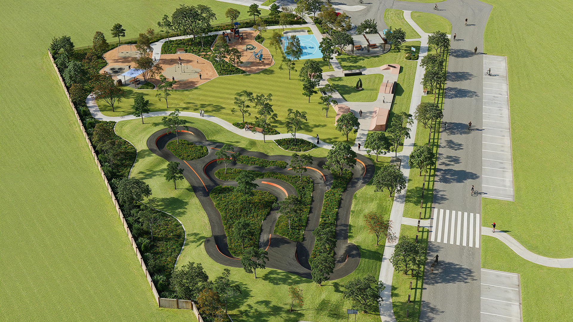
Types of 3D Site Plan Renderings
- Residential
- Commercial
- Landscape
- Master Plans
The type of 3D site plan rendering you choose should depend on the aims of your project and the people you want to reach. Residential and commercial renderings are great ways to show off layouts, amenities, and functional spaces in a way that makes it easy for purchasers, tenants, or investors to see them. Landscape visualizations can show how valuable outdoor spaces and natural elements are, which may be a big selling point for communities that care about lifestyle and sustainability. Master plans give a big-picture, strategic view of significant projects. They are necessary for getting government approval, getting finance, and making sure that the long-term vision is in line with what stakeholders expect.
The Real Business Benefits of 3D Site Plan Rendering
Visual Appeal and Realism – Making the Project Instantly Understandable
First impressions are important. A 3D site plan can grab the attention of decision-makers right away by showing the project in a way that makes it look real and ready to build. Realistic lighting, materials that look like they belong, and proportions that are right make people feel like they can trust the quality of the design.
Improved Stakeholder Communication – Bridging the Technical Knowledge Gap
Not every stakeholder speaks the language of blueprints. 3D site plans make it easy for everyone—from investors to community members—to grasp the scope and value of a project without technical translation. This reduces misunderstandings and keeps all parties aligned.
Faster Approvals and Permits – Convincing Boards and Regulators
Planning boards and local governments are more inclined to accept projects when they can see how the design fits in with the area around it. A well-done 3D site design takes care of problems before they happen, which can speed up the approval process. RIBA also highlights how visual clarity helps navigate planning procedures effectively.
Stronger Marketing and Pre-Sales Impact – Turning Interest into Sales
For real estate developers, being able to sell before building starts is a big plus. You can utilize 3D site plans in brochures, websites, and presentations to get people interested in buying, get deposits, and build excitement before the first foundation is laid. Our Real Estate Rendering Services are designed to do exactly that.
Early Error Detection and Cost Savings – Avoiding Expensive Revisions
Spotting inconsistencies or design flaws early is far cheaper than fixing them during or after construction. 3D site plan renderings allow teams to identify and correct potential issues before they become costly mistakes, ultimately protecting budgets and timelines.
Where 3D Site Plan Rendering Creates the Most Impact
Real Estate Marketing Campaigns
Pre-construction sales are no longer a challenge when buyers can see exactly what they’re purchasing. 3D site plan renderings bring developments to life in brochures, property websites, and digital ads, helping to secure early commitments and build anticipation before ground is even broken.
Investor Presentations and Pitch Decks
A 3D site plan gives to the Investors a full visual overview layout, amenities, and surrounding context allowing them to assess the feasibility quickly.
Master Planning and Urban Design
Large-scale projects require clear communication between planners, government bodies, and the public. 3D renderings make it easier to visualize infrastructure, traffic flow, green spaces, and community integration in a single, comprehensive view.
Hospitality and Tourism Projects
Site plans that show off scenic layouts, pathways, and amenity zones are good for resorts, hotels, and leisure projects. It gives possible guests a sense of the place and the experience before they get there.
Environmental and Sustainability Planning
When stakeholders can see how green spaces, renewable energy installations, and environmental buffers fit into the overall design, it’s easier to talk about sustainable development. ArchDaily often features projects that use such visuals to build public support and secure government approvals.
The Process of Creating a 3D Site Plan Rendering
The first step is to get accurate base files, such as CAD drawings, architectural plans, and topographic surveys, to make sure the site has the right size and layout.
Next, the layout is designed in sophisticated 3D software, where buildings, roads, walks, and landscaping are included in the right sizes. The model comes to life with realistic textures, lighting, plants, and other features that show where it is. The final photographs are made with high-quality rendering tools, and post-production improves colors, contrast, and environmental effects. Depending on the project’s marketing or technical objectives, deliverables can be still photographs, aerial views, 360° tours, or interactive maps. Explore more in our 3D Architectural Visualization services.
Advanced Formats and Technologies for 3D Site Plans
3D Aerial Site Plans – Best for Large-Scale Developments
It shows the property from above, giving a clear view of the entire layout. Stakeholders can quickly understand the size, design, and how everything connects.
Interactive and VR Presentations – Immersive Experiences for Buyers and Investors
Enable stakeholders to explore the site virtually, moving through different vantage points and zooming in on details.
Animated Walkthroughs – Storytelling for Marketing Campaigns
A cinematic presentation that guides viewers through the property, showcasing key features in a narrative style.
AR-Integrated Site Plans – On-Site Previews Using Mobile Devices
Augmented reality overlays the digital site plan on the physical environment, letting users visualize the development in its real-world location.
Common Mistakes That Hurt Your 3D Site Plan’s Effectiveness
- Overcrowding the design with unnecessary details – Clutter can overwhelm viewers and distract from the main selling points.
- Ignoring accurate scaling and proportions – Even slight inaccuracies can damage credibility.
- Using unrealistic colors or textures – Overly stylized visuals may look appealing but can create false expectations.
- Failing to tailor visuals to the target audience – A marketing render should focus on aesthetics, while a technical render should emphasize compliance and specifications.
How to Choose the Right 3D Site Plan Rendering Service
The portfolio is the first step in selecting the best 3D site plan rendering provider. Seek out variety, style, and quality that align with your goals. Experience in the industry is also important. A provider who understands your sector will know your audience, difficulties, and regulations.
Verify if they can manage the scope of your project and satisfy your deadlines. Pay close attention to the pricing. Communication that is responsive and clear is crucial. It minimizes delays and maintains project alignment. The National Association of Home Builders (NAHB) recommends evaluating both technical capability and service quality when making your choice.
To get a personalized session on this, feel free to contact us.
The Future of 3D Site Plan Rendering in 2025
AI-Assisted Visualization in Modeling: AI tools are making modeling faster and easier without lowering quality.
Real-time rendering adoption: Platforms for real-time rendering let you make design changes on the spot while stakeholders talk.
Visuals that focus on sustainability: Renderings are now showing more and more renewable energy systems, green roofs, and landscaping that is good for the environment.
Integration with BIM and Smart City Data: Combining BIM with geospatial and smart city data creates powerful tools for urban-scale planning and collaboration.
Frequently Asked Questions About 3D Site Plan Rendering
How much does a 3D site plan rendering cost?
Costs vary based on complexity, size, and deliverables.
How long does it take to create a 3D Site Plan Rendering?
A simple project can take 3–5 business days. Complex projects may require 1–2 weeks.
Can 3D site plans be interactive?
Indeed, they can be turned into 360° virtual tours, VR experiences, or clickable maps.
What’s the difference between a 2D and 3D site plan?
2D plans are flat diagrams ideal for technical work. 3D plans offer depth, perspective, and realistic visuals for easier understanding and stronger persuasion.
Who typically uses these services?
Developers, architects, landscape designers, urban planners, construction firms, and marketing agencies.
What files do I need to provide?
Typically CAD files, architectural drawings, surveys, and any reference imagery of materials, colors, or landscaping.